

Ali North Line Photography Tour 16 Days 15 Nights
- /img/1443362.jpg
- /img/14433416.jpg
- /img/14432920.jpg
- /img/14432864.jpg
- /img/14432795.jpg
- /img/14432744.jpg
Detailed itinerary
Lhasa Yanghu Jiangzi Shigatse
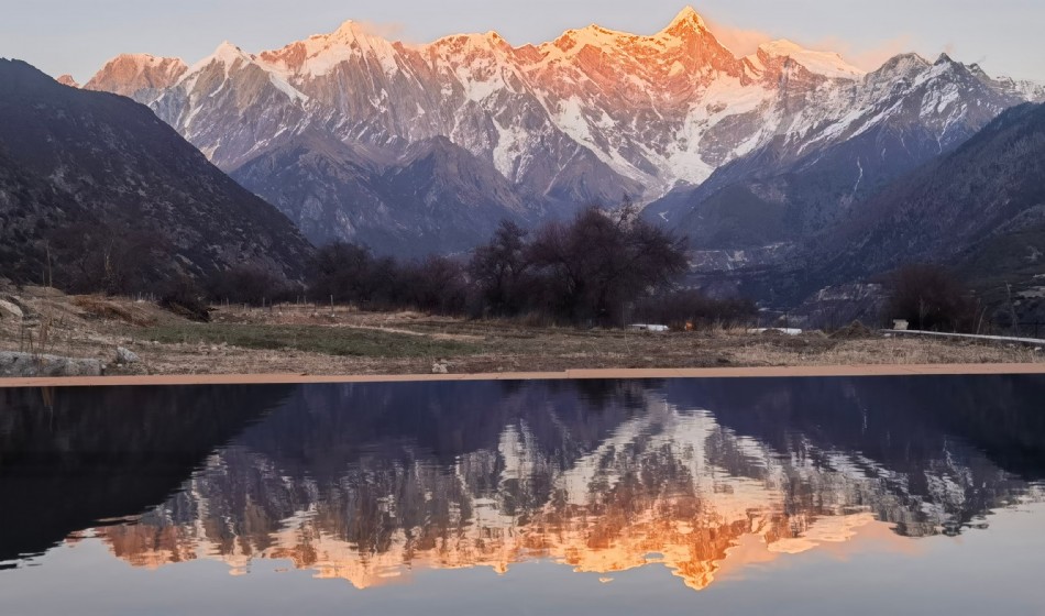
Departing from Lhasa in the morning, we climbed over the 4990 meter high Gangbala Snow Mountain, overlooking the Gangbala Radar Station, and followed the old road to reach the world's highest freshwater lake, Yangzhuoyong Lake, known as the "Holy Lake in the Sky" (with a lake surface elevation of 4441 meters, a shoreline of 250 kilometers, and an area of 638 square kilometers). It means "Jasper Lake" in Tibetan, and is one of the three holy lakes in Xizang. The water is as clear as sheep fat, sweet and drinkable. This is also the filming location for the movie 'Red River Valley'. The deep blue lake water blends seamlessly with the distant snow capped mountains, along with colorful mountain ranges on both sides, distinctive Tibetan villages, and abundant cattle and sheep. Walking all the way, it is refreshing and invigorating. Viewing the Karura Glacier on the way: It is like a sleeping ice beauty (crystal clear and blue, majestic and spectacular, misty and misty, unparalleled beauty, not only a geological history written by flowing years and ice, but also a great artwork carved by time). Visit Baiju Temple, the only 100000 pagoda temple integrating the three major sects in Xizang and famous for its exquisite murals and carvings, and visit Zongshan Anti British Battlefield (the heroic site of anti British heroes and the style of Hero City); Arriving in Shigatse by car, you may be fortunate enough to see Buddhists taking three steps and bowing their heads devoutly on the snowy plateau, measuring the pilgrimage path with their flesh and blood, and trekking towards the holy land in their hearts.
Shigatse - Tashilhunpo Monastery - Mount Everest
Visit the Zhashilunbu Temple, which has been the residence of the Panchen Lama throughout history. The temple was built in 1447 and is one of the six major temples of Huangjiao. It was also the residence of the Panchen Lama Erdeni throughout history. Looking into the distance, the entire temple is built against the mountain, backed by a high mountain, with connected halls and stacked buildings. The towering main buildings with golden roofs and red walls are magnificent, rich, spectacular, and resplendent. The purple smoke rises from the incense burner in the temple, and the lights on the altar twinkle. The various Buddhas have different appearances. The monks in the main hall chant scriptures in an orderly manner; In front of the Buddha statue, believers pay homage and worship. For over five hundred years, it has strongly attracted Buddhist believers from home and abroad, and visitors worship and observe here. The temple houses the world's largest indoor bronze statue, Qiangba Buddha, which stands at 26 meters tall, and visitors can also admire the stupa of the 10th Panchen Lama. In the afternoon, arrived at the world's highest altitude Mount Everest Nature Reserve. Looking south from the highest temple in the world - Rongbuk Temple (self funded), this is universally recognized as the best location to admire Mount Everest. This temple, located at an altitude of 5100 meters, has a towering white pagoda and colorful prayer flags dancing. Take an eco-friendly car to reach the base camp of Mount Everest at an altitude of 5200 meters. Here, you will dance with the world's highest peak, Mount Everest, and be fortunate enough to see the flag clouds of Mount Everest drifting like the flame of life.
Mount Everest Rongbuk Temple - Saga
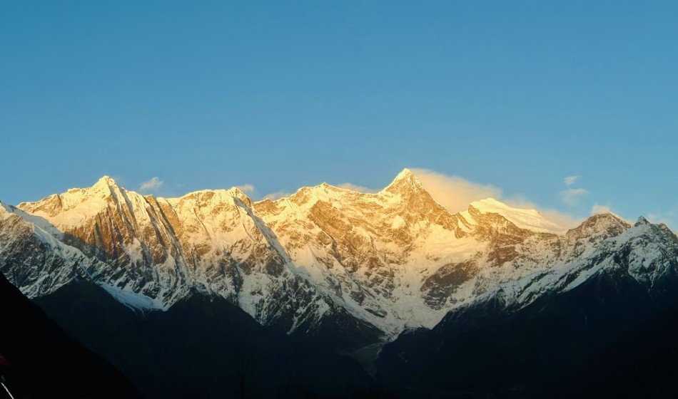
Along the way, you can watch the Xixia Bangma Peak, which is located in Nyalam County, northwest of Mount Everest. It is one of the peaks of the the Himalayas, with an altitude of 8012 meters, and is the 14th world famous peak. The northern slope of Xixiabangma Peak has a complex terrain, with steep mountains covered in ice cracks, and frequent occurrences of ice avalanches and avalanches. The largest Yebokanggal Glacier on the northern slope winds like a jade dragon in the mountain stream, and the ice tower forest is like scales, with clear and transparent layers. The southern slope of Xixia Bangma Peak has a warm and humid climate, with alpine rhododendron forests reaching an upper limit of 4700 meters above sea level. Below 3500 meters above sea level, the bamboo forests are lush green, and precious sunbirds, long tailed langurs, and red pandas can be seen everywhere, either in groups or individually.
Sagar Zhongba Paryang
Payang Grassland: Payang is a small town in Zhongba County, with a strong western style. Here, you can enjoy the unique clothing of Tibetan residents, as well as the leisurely stroll of cattle and sheep between the green grassland and the snowy mountains, creating a picturesque pastoral scenery. Along the way are amusement parks for wild animals such as yaks, Tibetan antelopes, yellow sheep, and Tibetan wild donkeys. There are numerous towering and stunningly beautiful snow capped mountains here, which are steep, varied, and majestic; There are countless lakes and vast grasslands stretching endlessly.
Payang Mayou Bridge Shenghu Mabang Yongcuo Shenshan Gangren Poqi 280 kilometers
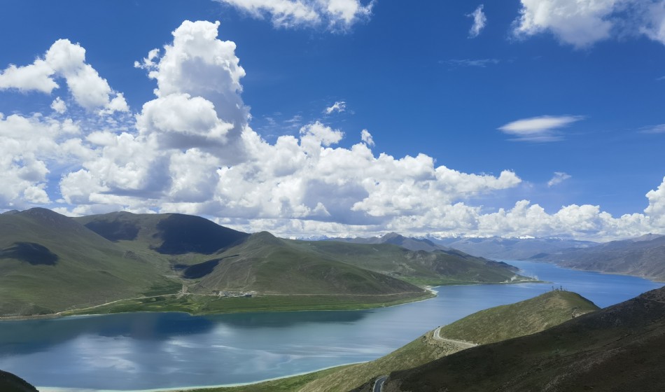
Mapan Yongcuo: Located 20 kilometers southeast of Mount Gongrenbo Qi and north of Namunani Snow Peak, with an altitude of 4588 meters and an area of 412 square kilometers, the deepest part of the lake can reach 70 meters. In terms of size, depth, and altitude, it is difficult to rank among the "best" lakes on the Qinghai Tibet Plateau. But in the plateau lakes, it is revered as the highest and most precious "queen", and is revered as a sacred lake by multiple religions such as Bon, Tibetan Buddhism, Hinduism, etc. It is one of the most famous lakes in Asia and even the world. Believers believe that Manasarovar is the nectar bestowed upon people by the Buddha, which can cleanse the skin of impurities, cleanse the mind of the five poisons, and prolong life. Therefore, anyone who comes to Zhuanhu will take a bath here and then bring back some lake water as a gift for friends and family. When the weather is clear, the lake water is blue with gentle waves, reflecting white clouds and snow peaks. The distant mountains around the lake are faintly visible, and the scenery is extremely beautiful.
Mount Kailash: The main peak of Mount Kailash, with an elevation of 6638 meters, is called "Shiva's Paradise" in Sanskrit and "Mountain of Gods" in Tibetan. Mount Kailash is shaped like a pyramid (referred to as the "handle of a stone mill" by Tibetans), with very symmetrical walls. Looking from the south, one can see its famous symbol: the Buddhist swastika (a symbol of spiritual power in Buddhism, meaning the eternal existence of Buddhism, representing auspiciousness and protection) composed of a huge ice trough vertically descending from the summit and a horizontal rock layer. Mount Kailash is often shrouded in white clouds, and locals consider it fortunate to be able to see the summit.
Staying at the sacred mountain and lake for filming
All day shooting in Tachin for the Divine Mountain - Gangren Poqi and the Holy Lake - Mapanyongcuo.
Shenshan Gangren Poqi Zada 350 kilometers
Zada: From Shiquan River, head south along the Ria Highway and drive 255 kilometers into the Xiangquan River Valley to reach AliZada County. Zada County has a famous scenic area of earth forest landform. Tulin is a special landform formed in ancient times by the influence of mountain building movements, where the sedimentary layers at the bottom of the lake were cut by flowing water for a long time and gradually weathered and eroded. The "trees" in the earth forest are staggered up to tens of meters high and low, with various shapes and unique charm. During the journey, the car seemed to spin around the feet of numerous giants.
Full day shooting of the Guge Dynasty and Zada Tulin 80 kilometers
Go to the ruins of the Guge Kingdom, 7 kilometers away from the county town, to watch the sunrise. When you look up at the magnificent Guge Palace, you will find that the layout of this 300 meter long earthen mountain is rigorous, arranged in a hierarchical manner from top to bottom, with various remaining halls, caves, watchtowers, pagodas, protective walls, etc. scattered among them. From this, you can imagine the grandeur of the palace at that time. After the tour, return to Zada County along the original road and visit the over 900 year old Tolin Temple after lunch. The temple combines the architectural style and Buddha statues of Indian Kashmir, Ladakh, and Nepal. More than 100 ruins of Buddhist pagodas can be seen around the temple, and ancient murals are preserved inside, which can imagine the glory of the temple in the past.
Zada Guge Site Shiquan River 280 kilometers
Guge Ruins: The predecessor of the Guge Dynasty can be traced back to the Zhangxiong State. The establishment of the dynasty began in the 9th century, after the collapse of the Tubo Dynasty, which unified the Xizang Plateau. By the end of the 17th century, 16 kings had been inherited. It was a local government established by the descendants of the Tibetan royal family in the Ali region of western Tibet, with its rule covering the entire Ali area at its peak.
Shiquan River Town (Gar): Located at the intersection of Shiquan River and the Xinjiang Tibet Highway, it is the central town of Ali region.
Shiquan River - Bangong Lake - Shiquan River 300 kilometers
In the morning, we set out for Bangong Lake, the most famous bird lake in Xizang. Hundreds of birds live in the lake, which is a paradise for birds in Xizang. Return to Shiquan River in the afternoon.
Shiquan River -220 kilometers from Sun to Earth
Departing for Jutu, take a bend and climb a slope outside the county town to get a panoramic view of the county. The car travels along the dirt road, weaving through the mountains and fields. Along the way, there are large wetlands where flocks of wild ducks, grey ducks, and geese swim. Not long after, there was a rock painting relic on the cliff on the right side of the highway, which was the Renmudong rock painting. Due to lack of protection, the few remaining rock paintings are being eroded by wind and rain. The six character proverbs, characters, and animals carved on the rocks, although rough in technique and simple in lines, are vividly shaped. Not long after continuing forward, we arrived at the border county of Ritu. After passing through the county town for 9 kilometers, we arrived at Bangongcuo Lake at an altitude of 4242 meters. The lake is connected to Kashmir, with freshwater lakes in China and saltwater lakes in Kashmir. For lunch, we tasted the plateau carp family split belly naked fish, a specialty of Bangong Lake, by the lake. After the meal, we took a boat to the center of the lake - the world's highest bird island, where tens of thousands of birds flew and the scene was extremely spectacular. There are countless bird nests and eggs, and a large number of brown headed gulls, wild ducks, grey ducks, and geese come here to breed.
Japan and Turkey - Change to 500 kilometers
Departing for Gaize, having breakfast in the car, the sky was still dark and the stars seemed to be within reach. The car continued to drive on the wilderness and soon arrived at the first lake, "Rebangcuo". The convoy continued to move forward, with groups of wild donkeys and yellow sheep occasionally provoking and racing against the cars. There were hardly anyone or anything along the way, except for an occasional small white tower on the mountaintop, indicating the presence of religion here. After passing through Lake Awongcuo and meeting the road, we arrived at the chaotic salt lake town. After lunch, we continued to shuttle through the wilderness, passing through lakes of different sizes, and finally arrived at the hinterland of the northern Tibetan Plateau - Gaize. Alternatively, it would be a larger county town in the wilderness, with all kinds of facilities readily available.
Change plan - Dongcuo - Nima 421 kilometers
Depart for Gaize, have breakfast in the car, and drive back to the wilderness. Soon, you will arrive at the first lake "Dongcuo", where you can see the magnificent sunrise of the plateau lake if the weather is good. After branching off at Dongcuo Town and Xiaobei Line, the convoy continued to move forward and passed by a beautiful plateau lake called "Zhaxicuo" on the roadside before entering the Nagqu boundary. The car has been driving on the wilderness all along, and the mountains on the edge of the wilderness extend like they have no boundaries, lonely and desolate. After crossing the Chalanmula Pass and entering the Qiangtang National Nature Reserve in northern Tibet, you can have a road lunch or enjoy Lanzhou Lamian Noodles at a roadside car stop. After dinner, you can continue to cross the wasteland. Groups of wild donkeys and gazelles sometimes challenge and race beside the car. If you are lucky, you can see foxes and Tibetan antelopes. After passing through various sizes of Liangzi and passes, we arrived at Nima County, located on the Qiangtang grassland at an altitude of 4500 meters.
Nima Bangor 350 kilometers
Depart for Bango and have a roadside meal in the car. The car still travels through the endless wilderness, but today we encountered many large and small lakes. We passed by the small lake Zhangnaicuo, then Wu Rucuo Lake, and after lunch in Nancuoze Town, we continued to drive at the roadside tent restaurant. That evening, we arrived in Bango County, located between the two large lakes of Namtso and Selincuo.
Bango Namtso 240 kilometers
Departing for Namtso Lake, the car finally diverged from the Qiangtang in northern Tibet and headed south. The car went up and down the Bango Grassland, with lakes of different sizes each having their own characteristics. Along the way, a larger divine lake called "Bangcuo" could be seen, where snow capped mountains, grasslands, and villages complement each other beautifully. For lunch, we had a roadside meal, and then continued on our journey. The car kept shuttling through the earth, crossing a snowy mountain pass, and we could see the panoramic view of Namtso. The Nianqing Tanggula Mountains guarded the Shenhu Lake, which was very beautiful under the sunshine. Go down the mountain and enter the Namtso Lake, which is known as the "Heavenly Lake". This lake is one of the three sacred lakes in Xizang, the largest lake in Xizang, and the second largest salt lake in China. On the Zhaxi Peninsula extending into the center of the lake, there is Zhaxi Temple, both of which are famous pilgrimage sites. After tidying up, everyone can go out to visit the island and lake, visit the Husband and Wife Stone, Palm Stone, Manidui, and small temple. They can also climb to the top of the island to take photos of the divine lake. Along the way, you can also overlook the main peak of the Nyenchen Tanggula Mountains at an altitude of 7717 meters.
Namtso - Lhasa
Watch the sunrise at Namtso in the morning, then pass through the vast Qiangtang grassland, Nianqing Tanggula Mountain, Yangbajing, and return to Lhasa in the evening. The trip is over.
Cost Description
- Travel days: 16 Days 15 Nights
- place of departure: Lhasa
- Brief itinerary: Mount Everest Base Camp, Tashilhunpo Monastery, Mapanyongcuo, Guge Dynasty, Zadatulin, Bangong Lake, Namtso
Customize your own travelWe will provide the most suitable solution for you based on your needs
 Scan the QR code on WeChat
Contact us anytime
Contact Us
Tel:+86 136 4890 6777
WeChat:+86 136 4890 6777
E-mail:info@htitgroup.com
Q Q:517667613
- Add WeChat
 Mobile Access
 QQ
QQ Mobile
 Home
Home